GPS Map Camera App was created to solve a simple problem. Photos alone do not prove where work happened. Many professionals depend on location records every day. We built a camera that records context inside the image.
The goal was clarity. A person should understand a photo without extra explanation. The image itself should show place and time.
Our Purpose
Work documentation often becomes complicated. People capture photos and later prepare reports. That process wastes effort and causes mistakes.
We designed the app to record details during capture. The photo becomes the report. This reduces manual tracking and confusion.
Why We Built This App
Most camera apps focus on filters and editing. We focused on accountability and clarity. The app was designed for real world usage.
Field Workers
Field workers needed faster verification methods to prove their presence and work quality.
Client Trust
Clients needed reliable confirmation that service level agreements were being met.
Team Velocity
Teams needed simple reporting that didn’t involve hours of manual data entry after a shift.
Our Latest Blogs
Best practices, troubleshooting tips, and compliance advice for capturing reliable location proof images.
Have any doubts about GPS Map Camera app? Here are some frequently asked questions that should answer most of yours.
Yes. GPS Map Camera is available for both Android and iPhone. You can capture photos with GPS location, address, date, time, and map overlay on both platforms.
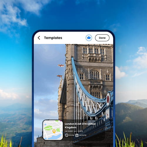
Yes. GPS Map Camera works as a timestamp camera. It adds the date, time, GPS location, and address to every photo automatically during capture.
Yes. The app displays latitude and longitude directly on the photo at the time of capture. This creates precise location records useful for fieldwork, surveys, and documentation.
Yes. The app detects your GPS position the moment you take a photo. It converts the coordinates into a readable address automatically. The address appears as a visible stamp on the saved image.
The stamp is applied at the moment of capture, not added afterward. Editing the image file does not alter the original location or time data. This keeps the photo trustworthy as a field record.
Accuracy depends on the GPS signal strength of your device. Open outdoor areas provide the highest precision. GPS Map Camera always records the strongest available signal at the time of capture.
The app uses optimized GPS access to keep power consumption low. It is designed to run reliably during full-day field sessions. Battery usage stays controlled even with continuous location tracking.